Tama
Tama County
Indians called Iowa “the Beautiful Land”. The Sioux and Dakotas selected this land we know as Tama County as a camping ground. It had vast and rolling prairies, with many prairie flowers and animals. The largest river in Tama County is the Iowa River and it has 7 other named creeks that run through it. There are several different types of limestone found in Tama County.
The Sac and Fox were formerly two distinct nations living near the St. Lawrence River and the U. S. government treated them as one people. The French had named the Sockees as the Sac and the Musquakies as Reynard (which means Fox). The Sac accepted their name, the Fox did not. They preferred their Musquakie name meaning “red man” or “red people”. To the European white man, they became the Sac and the Fox.

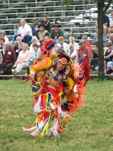
Pow Wow Dancer ©Peter Hoehnle
The Fox moved further west and reduced their numbers through war with the French. The Sac were involved in war with the Iroquois, who occupied what is now New York State. Both were weak in force. So as the Sac moved west, they joined forces with the Fox and in the sense of association, became one people. They branched out to Iowa, Missouri, and Wisconsin. When the Black Hawk purchase was made, a portion of the state of Iowa was retained by Indians (400 sq. miles) and was known as ”Keokuk’s Reserve”. In 1803, the French ceded the Province of Louisiana to the U. S. Government. Iowa was in the possession of the tribes of the Sac and Fox, who were at the time acting as confederate tribes. After 1803, Indians ceded by treaty, tract after tract of Iowa land. The last treaty was in 1842 and they had no more land to give.
The Meskwaki used the lands in central Iowa for hunting, raising crops, tapping maple trees to create sugar, and to pick cattails to create mats to cover their wikiups. In the spring time, they left their village to move to the fields until crops were sown. Then return to the village in the center of the reservation. When the crops were matured, they moved back to the fields for harvest. In winter, they spread out and left for other parts of Iowa or along the rivers to make a winter camp as a wider area was needed to hunt for food.
When land was opened to the white man, they rushed at midnight on the appointed day to drive a stake into the earth and claim their piece of land. The Indians, who could be found, were removed to Kansas. There were 317 Meskwaki or Fox that after being removed, returned to Tama county. An Act on March 2, 1867 permitted the Meskwaki to receive their share of tribal funds, which is interest only on the amount due them from the Government for their lands. They began to buy land in Tama County- beginning with 80 acres. In 1881, there were 355 Meskwaki living on their purchased land.
The first white men to Tama County brought 2 wagons and needed all 9 horses to pull one wagon at a time through the Iowa mud. The first log cabin had to be rebuilt on higher ground due to hard rains and flooding. The first crops were pumpkins and corn. Northern Tama County was on a different path with settlers coming there came from Dubuque. Southern Tama County saw their settlers come from Davenport or Muscatine. Places further west were more settled than northern Tama County, which took much longer to settle and still has a sparse population. The Northern part of the county is now referred to as the Bohemian Alps.

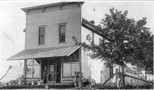
Gladstone
Tama County was surveyed in 1843, but attached to Benton County for revenue, judicial, and civil purposes because of its low population. In 1850, there were 16 people. By 1853, there were 200 county residents and in 1880, the number rose to 21,585. In 1853, the county officially separated from Benton County and elected its own officers.
Commissioners arrived in the area to select a county seat site and the owner of the selected site refused to donate or sell his land. Two local men persuaded 4 other men to each donate 20 acres as the commissioners would not accept a site less than 80 acres. Ogden, a commissioner, picked up a stake and drove it into the ground proclaiming the site as the county seat and Toledo got its name for the nearby post office that had been established that summer. The name “Toledo” comes from a book the postmaster had read, “Knights of Toledo in Spain”.
Roads and Trails in Tama County
Prior to 1883, pioneers traveling through the region usually followed trails and paths and kept the setting sun straight ahead and followed any devise to keep in the right direction. In July 1853, a State Road was laid out by legislature, running from Marengo to Ft. Dodge and crossed through the southern part of Tama County. In 1854, a mail route was established from Marengo to Marietta in Marshall County. Another recorded road in Tama County led to Hardin County. In 1853, a state road led from A.D. Stephens to Indiantown as it ran north from the Iowa River and streams were temporarily bridged. In 1854 and 1855, Tama roads led to Black Hawk County, from Vinton to Newton via Toledo, and from a mill in Toledo to Salt Creek. In many historical sources, it has been noted that private citizens built their own bridges to cross the many streams in Tama County.
There are many ways to explore Tama County today. Automobiles may travel the Lincoln Highway or the four-lane Highway 30. As you travel, you might spot the seventeen barn quilts that have been created as public art. If you want to stretch your legs, there are many walking trails like the C.R. Roberts Memorial Trail which connects Dysart to the old Creamery Nature Trail in Garrison and Vinton (two towns outside of Tama County). Or the Wolf Creek Trail that heads northwesterly and connects with the Comet Trail. Tama County has also embraced geo-caching and has over thirty registered sites for treasure hunters to use GPS-enabled devices to attempt to find the geocache (container) hidden at each location.
Tama County and the Lincoln Highway
The Lincoln Highway runs through the town of Tama, Chelsea and Montour and the outskirts of the Meskwaki Nation lands.
Towns on the Lincoln Highway:
Chelsea
Otter Creek Station was located one mile east of present day Chelsea. As the Chicago, Iowa, and Nebraska Railroad, later known as the Chicago and Northwestern, extended west the Station also moved west by ¾ mile and was renamed, Chelsea. The name either came from S.G. Brese who was originally from Chelsea, MD or possible from John Bair, naming it after Chelsea, England.
Floods have played havoc on this town over the years. The original steel bridge on the Lincoln Highway was replaced with the 1928-29 Otter Creek Bridge. The 1928-29 bridge was replaced in 2007 and citizens encouraged the preservation of the bridge lampposts which graced the old bridge railings.
An important historical site is the Haven Country School which was built in 1872 and today sits on its original foundation. It was closed for school purposes in May 1968, but was used again a few years ago when the Chelsea school was unusable for part of the year due to flooding. It was the last one-room school to close. For tours, call 641-484-6767 or email tracers@pcpartner.net.
The Otter Creek State Marsh is a 3,600 acre wetland complex 1.5 miles west of Chelsea on E66 and is home to thousands of waterfowl.
The Czech Trail runs north from Chelsea to Clutier and takes a side jog to Elberon at vining. This area is known as the Bohemian Alps.
The City of Tama was platted in 1862 and named Iuka in honor of the men who fought in battle at Iuka, MS. The county seat site had already been selected and Toledo began to grow. The Cedar Rapids and Missouri Railroad, now the Chicago and Northwestern, was planning on making Toledo one of it points. They wanted to place a depot on the line, near the Iowa River. But when it was actually built, it was 2 ½ miles from Toledo. The station was called Toledo Station. As the station was not located exactly near Toledo, the town that formed was named “Iuka”, later renamed “Tama City” and eventually just “Tama”. There are several version of what the name Tama is created from. It may be from the Indian word “Te-i-o-ma-ha’s” which means “the thunder that make the earth tremble” or for Taimah, a leader of the Meskwaki. Another source says it is in honor of the wife of Poweshiek and means “beautiful, pleasant, or lovely”. And yet another source says it is for the Indian chief “Pottama”. Whatever version you subscribe to, it has an Indian relationship.
Tama is best known for its Lincoln Highway Bridge built in 1915, which has the letters “Lincoln Highway” in the concrete side panels. It is one of the last remaining original structures of the Lincoln Highway. There is a small monument in a nearby park.

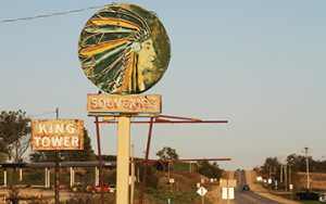
King Tower Cafe in Tama. Closed permanently in September 2020 due to COVID-19 and derecho damage. ©Michael Kelly
Another mainstay has been the King Tower restaurant with its iconic neon light. Tourist cabins once graced the area to the north and east of the parking lot.
The Meskwaki are of Algonquin origin from the Eastern Woodland culture area. Their language is the same dialect at the Sauk and Kickapoo. Historically they were located in the St. Lawrence River Valley, Michigan, Wisconsin, Illinois, Missouri, and Iowa. Their first contact with Europeans was in 1666.
In 1830, both Native Americans and Europeans started settling in Tama County as the Black Hawk Wars concluded. German and Czech settlers in the area learned some of the Meskwaki language and vice-versa. In 1845, the U.S. Federal Government mandated the Indians be removed to Kansas. Existing relationships with the Meskwaki led many European settlers to hide and protect them. Iowa was the first state to grant permission to Native Americans to buy land.
In 1857, the Sac and Fox Tribes of the Mississippi in Iowa (Meskwaki) purchased 80 acres. They now own 7,778 acres and have a sovereign nation and settlement designation. This is a unique distinction between the Meskwaki and most other tribes who reside on reservations.
The Meskwaki operate a casino, hotel, and convention center and are the largest employer in Tama County. In mid-July, the tribes of North America gather in Tama for Proclamation Day and in the first weekend in August, the Meskwaki hold their annual Pow-Wow.
Montour
In 1861 the Cedar Rapids and Missouri Railroad, later called the Chicago and Northwestern Railroad, reached to Marshalltown and towns formed along the line. One was the town of Orford, founded in 1863, near the villages of Indian Village, Butlerville, and Pleasant Hill on the east side of Indian Creek and south of the Iowa River. By 1865, the Orford post office was established. Townspeople had problems with their mail getting sent to Oxford, Iowa instead. The names were too similar, so the name was changed to Montour.
Today, Rube’s Steakhouse offers a “grill-you- own concept” and large cuts of meat. It is an anchor of the community.
Other Towns in Tama County:
- Clutier
The town was founded in 1909 by William Brice, a principal capitalist and promoter of railroad projects known as the Iowa, Minnesota, and Northern Railroad. He named the town after his sister and her husband, Mr. and Mrs. Bertram Clutier. It is the youngest town in Tama County and settled by Czech immigrants. It has a high concentration of caterers, who specialize in Czech cuisine including kolaches and rohlicky. The community holds a Czech Bohemian Plum Festival the first weekend in August and polka band concerts in the summer. A Czech Museum is housed in the western Bohemian Fraternal Association’s lodge building. Call 319-478-2477 to schedule a tour.
- Dysart
Platted in 1872, the town planned for growth as the Main Street is extra wide heading towards the park. The community once accepted children from “The Orphan Train”, a social experiment that transported orphaned, abandoned, or homeless children from crowded coastal cities in the United State to the Midwest for adoption.
- Elberon
The town was incorporated in 1883 and temporarily called Halifax. The named Elberon came from the community of Elberon, NJ where early settlers had come from. There is a handcrafted wooden train at the east side of town for children to enjoy.
- Garwin
In 1879 the Toledo and Northwestern Railroad was sold to the Chicago and Northwestern Railroad, who immediately started to extend the line to the northwest. Garwin was the first town created beyond Toledo after this expansion. It was first called Maple, or some say, Myrcle. These names were not liked, so Marvin was chosen. Another town already had that name. When a Mr. Rider and Mr. Galvizer agreed to sell their land to create the town, the message was sent to Toledo “G (for Galvzier) and R (for Rider) win”. This was construed as Garwin and the town had its name.
Today, Garwin is home to the Oakridge Motocross facility which has several racing tracks complete with starting gates. Address is 1324 280th St.
The founders of this town had to go to Chicago to fill out paperwork. When asked what was worthwhile in Iowa, they responded that they had a nice brook and were glad they had it. So it was named Gladbrook. The community holds the Gladbrook Corn Carnival every summer. The City Center houses the Gladbrook Museum, City Hall, a movie theater, and Matchsticks Marvels Tourist Center. Millions of matchsticks have been turned into works of art by Patrick Action since 1977. The City Center address is 319 2nd St and you can phone 641-473-2410 or contact glbktheater@iowatelecom.net for more information.
The Union Grove State Park is 282 acres around the Union Grove Lake. The address is 1215 22th St and the phone number is 641-473-4556.
- Lincoln
Charles Spencer wanted to give the town his name, but the name “Spencer” was already taken. So he chose “Augusta”, after his wife. That name was already taken too. His next pick was “Bellin”, after a town in Scotland that his wife loved. But it was misinterpreted and put on official maps and documents as Berlin. It was settled by German immigrants, so no one minded. After the outbreak of World War I, it was decided in an effort to show the town’s support to the United States, the name would be changed. Berlin became “Lincoln” on June 12, 1918.
The town site was selected in 1853 as the county seat. It was afraid if they did not hurry and raise money for a courthouse, they would lose the distinction of being the county seat. So money was raised and courthouse construction begun in 1865. The town kept trying to get the railroad to come through and finally in 1870, the Toledo and Northwestern branch was organized. The rail was 3 miles long. By 1872, the first “iron horse” steamed into Toledo. Then in 1879, this short branch was sold to the Chicago and Northwestern who pushed the line north to Hubbard.
Abraham Lincoln was award two parcels of Iowa land for his service in the Black Hawk war. One is located in Tama County. The site is 5 miles north of Toledo on Route 63 and then west 3 miles on 260th St to H Avenue, then turn north. You will see a marker on the east side of the road.
The Toledo community has many buildings listed on the National Register of Historic Places: the 1866 Tama County Courthouse, the Wieting Theatre built in 1912, the former Toledo fire station built in 1875 and renovated into a private residence complete with a swimming pool and elevator, the 1901 Hotel Toledo that is still in operation and boasts of elegant beamed ceilings and a grand fireplace, and the 1870 former County Jail which is now houses the Tama County Historical Museum and Genealogical Library. A restored log cabin sits outside the Museum.
Toledo has a bronze cow/calf sculpture at the intersection of Highway 30 and Highway 65 to honor Norma (Duffy) Lyon, a Toledo native. She is known in Iowa, across the nation and the world as the “Butter Cow lady”. For many years, she sculpted large pieces of butter into cows and other objects for displays at the Iowa State Fair.
Toledo holds an annual Stoplight Festival the 2nd Friday in July.
The town was platted in 1873 by John Traer when the Pacific branch of the Burlington, Cedar Rapids, and Northern Railroad came through. In 1894, an iron worker in Burlington was hired to construct a winding spiral staircase at 534 2nd St to access the Traer Star Clipper office, now on the National Register of Historic Places. It was a marvel of how a small space could be used at the time. Today, the community holds a Winding Stairs Festival every August.
The largest collection of salt and pepper shakers in the Midwest is in Traer with over 13,000 pairs of shakers on display. Address is 411 2nd St, Traer. Call 319-231-7654 for times.
- Vining
This is the smallest community in Tama County. It was platted in 1881 and is known as “The Littlest Town in the Bohemian Alps”.


