
Benton
Benton County
Benton County was established at the same time as Tama County and had been attached to Linn County for judicial, revenue, and election purposes. Much of the county was in the possession of Indians until 1843. A small portion had been bought from them in 1837 and people settled very close to the Indian line.
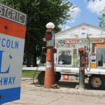
Fuel Station along the Lincoln Highway in Benton County
The typography is that of gentle undulating prairie with numerous groves of native and planted timber which dot the county. The soil in lowlands is sandy, but as prairie rises, the soil becomes a deep, black fertile soil. The county is well-watered and is adapted to raising stock. The Cedar River starts in Minnesota and enters Benton County in the northwest corner and travels in a southern direction, then flows easterly. It is a very crooked river and flows for a total of 40 miles in the county. The Iowa River flows about 2 miles across the southwest corner of the county and Big Creek flows northeast to Black Hawk County. There are 11 other creeks in Benton County.
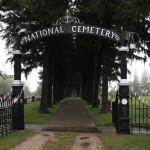
Gate to National Cemetery ©Mike Kelly
There are many groves of oak, hickory, maple, walnut, ash, basswood, elm, cottonwood, willow and hackberry. The quarries in Vinton and along the Cedar River have excellent stone for building and the stone was used at the Iowa State College for the Blind in Vinton.
The first county seat was in Northport. It was laid out in 1846 and soon the sale of lots took place with bids submitted, but the sales never consummated. The plat was never recorded. The town finally built a courthouse in 1846 and the town platted in 1848. It was named Vinton to honor a member of Congress from Ohio. Several times it was put to a vote to move the county seat closer to the river.

Woman in Vintage Car at Youngville Café © Mike Kelly
A group of outlaws and thieves came from Ohio and Indiana and settled in the area near the Cedar River. Honest settlers organized as Regulators/Vigilantes and 500 of them tried, condemned, and shot two of the outlaws. Many houses were used as a refuge or hiding place for their accomplices in crime. These outlaws operated in Cedar, Linn, and Benton Counties. Horse stealing was very common. Sometimes the outlaws were elected as constables and Justices of the Peace in an attempt to protect the criminals from the law. The Iowa Protection Company was created by honest residents to protect their property and horses.
Towns along the Lincoln Highway in Benton County
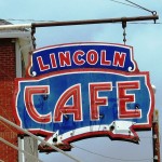
Lincoln Café in Belle Plaine © Peter Hoehnie
Belle Plaine was platted in 1862. On July 28, 1894 the business district was consumed by fire at 5:30 AM. There was a quick response, but the residents could see it would be a battle. Whole buildings were soon engulfed and help came from Cedar Rapids, Blairstown, and Tama aboard special trains furnished by the Northwestern. The $30,000 Opera House melted away as if made of paper. The fire consumed five solid blocks of the town with eighty businesses lost. It caused a half a million in damages and there was only $200,000 in insurance coverage.
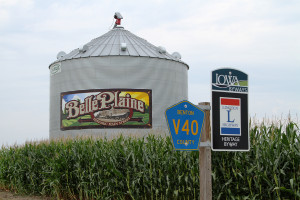
Lincoln ByWay sign in Belle Plaine in front of their grain bin. Destroyed on August 10, 2020 in derecho (in-land hurricane). ©Mike Kelly
The terminus of the Clinton Division of the Chicago & Northwestern is located here with a roundhouse and machine shop. The town was laid out in 1860 on the northern slope of the Iowa River. “Belle Plaine” means “Belle of the Prairie” or “Beautiful Plain”. Deer, waterfowl, and fish were plentiful.
In 1886, as a well was being drilled, water sprang up 53 feet in the air causing what is now known as the “Jumbo Well”. It took 14 months to harness the well. Several other artesian wells are in the area.
Today, the Belle Plaine Area Museum houses much of the town’s history. The town celebrates Jumbo Well Days every year. For more information see.
Kirkwood Community College has a campus in Belle Plaine.
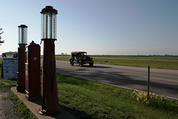
Gas pumps by the Youngville Cafe on the Lincoln Highway. ©Mike Kelley
This is not a town, but is one of the few remaining rural filling stations and eateries in the State of Iowa. (The Lincoln Highway only passes through one town in Benton County -Belle Plaine). A group of volunteers, organized in 1997, were committed to preserving these buildings. Today the Youngville Café Welcome Center and Museum is listed on the National Register of Historic Places and is operated solely by volunteers. Call 319-223-5289 or visit their website for more information and hours of operation.
Benton County and the Lincoln Highway
A 1878 book noted, “Since incorporation of Belle Plaine, hundreds of dollars have been expended on the roads in the vicinity of the Iowa River, which although necessary, has been a heavy burden on this enterprising town.” In the 1920’s, the Lincoln Highway came through Belle Plaine. The first transcontinental road brought many travelers to town.
Other Towns in Benton County
In 1855, the US Government donated forty acres to Levi Pangborn and he sold pieces of the land to several people. The town was settled in 1881 under the name “Hague”. The Chicago, Milwaukee, and St. Paul Railroad came through the area. Atkins is the midway point between Chicago and Omaha. Local freight and passenger service to Cedar Rapids was established the following year and it made two stops a day in town. Early Germans did not like the town’s name and called it “Poker Flat” because of a local storekeeper who sold warmed beer in the winter with a red-hot poker, which gave it a flat taste. The Milwaukee Land Company laid out the streets and renamed it Atkins. In 1953, passenger service stopped and freight lines ended in 1980.
- Blairstown
The Chicago &Northwestern railroad laid out the town in 1862 and named the town for John I. Blair, the president of the Blair Town Lot and Land Company, who was affiliated with the railroad.
The town was laid out in 1872 and was named Benton. When the railroad started working on the branch line from Vinton in 1873, they called this little stop “Benton Station”. In 1873, the first post office was established on ground owned by the Garrison family. The name changed from Benton Station to Garrison in 1877 because another town in the county was already called Benton. Garrison once had 3 churches, a weekly paper, 2 grain elevators, and a canning factory. A fire in 1911 took 26 buildings. The town never quite recovered from the disaster.
- Keystone
Keystone was platted in 1881 when the Chicago, Milwaukee and St. Paul railroad extended to that point.
- Luzerne
The Chicago & Northwestern wanted a station midway between Blairstown and Belle Plaine. In 1867, the station was moved from Buckeye to the prairie 2 miles west. The town was platted in 1868 and some of the buildings were moved from Buckeye to Luzerne. The landowner, Howe, named it for a place in Switzerland.
- Mount Auburn
This town is located on a high point and Vinton, the county seat, can be seen from here. The railroad’s side track of Mount Auburn was laid in 1870 and a turntable which had been placed here because it was a temporary terminus of the road, was taken out and moved to LaPorte.
- Newhall
The town was named for John B. Newhall of Burlington. He was a well-known speaker and author in Iowa prior to 1850 and a strong advocate for the territory and state of Iowa. In May, 1916, a “pest shack” was erected for people ill with smallpox. During the month, three cases developed and the homes the three families were under quarantine. Six other people were either infected or exposed and instead of restricting these residents, they were housed in the “pest shack” for 6-19 days.
In July 1916 a fire broke out and several businesses were lost with $90,000 in property damage.
- Norway
In 1863, a Norwegian farmer donated 5 acres to the Chicago & Northwestern with the stipulation they needed to name it after his homeland. The first settler, O.B. Button lived in a freight car until his house and store was built. He was in charge of the railroad station.
- Shellsburg
In 1854, the town was surveyed. John Sells was one of the early settlers and he wanted his name on the town, but some proprieters wanted a different name. They finally compromised on Shellsburg. To the north of town it is heavily wooded and this was a good place for thieves and outlaws to hide. The timber to the east presented the town with the opportunity for a profitable business of making hundreds of railroad ties and bridge timbers which were shipped from this station. The town had a few destructive fires over the years.
- Urbana
Marysville was laid out in 1847 and was nicknamed “Hoosier Point”. The post office was called Urbanna. In 1857, the government changed the name to Urbanna because of other towns by the same name. In 1880, the second “n” was dropped. In 1887, the railroad built near other towns causing Urbana very slow growth. In 1905, a big fire destroyed 13 buildings.
- Van Horne
The town was named after Sir William Cornelius Van Horne, the Chicago and Milwaukee railroad superintendent. It was described in 1883 as the “New Village”. Today, they hold an annual Music Festival the second Saturday in June.
The town was first called Northport, then Fremont, and finally changed to Vinton to honor Plynn Vinton, a US representative from Indiana. In 1852, Prof. Samuel Bacon established an Institution for Instruction of the Blind in Keokuk. The town of Vinton donated $5,000 towards a new building, if the Institute would move to Vinton. In 1862, the building in Vinton was completed.
This town lies in both Benton and Linn County.
The town was platted in 1874. The railroad station is midway between Blairstown and Florence. The town name is in honor of railroad Supt. Watkins who lost his life in a railway collision in October 1873.

 1914. Belle Plaine.")

. \"The Swellest Little Hotel in Iowa.\" 1914. Belle Plaine.")

. Note Lincoln Highway sign on telephone pole. Message to Gainesville NY: \"Dear Ma and Pa, We got here about 5 o'clock Saturday night. They were looking for us so had supper all waiting. We stayed in Tourists' Camps two nights. It is certainly great to travel. There was State Road all the way. Isn't this a nice looking place? Remember me to all who might inquire. Love from Myrtie\" October 26, 1931. Belle Plaine.")
